LINCOLN SOIL AND WATER CONSERVATION DISTRICT
  • Home
  • Events
  • Services
    • Resources >
      • Technical Assistance
      • Invasive Species Control
      • Poisonous Plants of Lincoln County
    • What We Do >
      • Watershed Restoration, Enhancement, and Assessment >
        • Watershed Enhancement >
          • Siletz Focus Area
          • Technical Assistance >
            • Streambank Erosion
          • Conservation Plans
          • Conservation Incentive Programs
        • Water Quality Monitoring
      • Fish Surveying and Aquatic Habitat Asessment
      • Invasive Species Control
    • Partners
  • Contact Us

Mid-Coast Monitoring Program

Spawning Survey and Aquatic Habitat Monitoring

Our Goal is to Document the Environmental Responses to Conservation Practices through Species Monitoring to Evaluate their Effectiveness to the Local Ecosystem.
Steelhead Population Trends
Salmon Population Trends
What do we monitor?
  • Stream Restoration Projects
  • Fish Passage Improvement Projects
  • Fish Usage in Project Areas

What methods do we use? 
  • Pre & Post Project Aquatic Inventory (Habitat)
  • Direct On-ground Observations
  • Adult Spawning Ground Surveys for salmonids

Aquatic Habitat Inventory Process 
  • Pre and post project Aquatic Habitat Inventory following ODFW protocols
  • Qualifying & quantifying: Habitat Units, Stream Gradient, Substrate, Unit Length & Wetted Width, Channel Morphology, Channel Metrics, % Shade, % Undercuts, % Active Erosion, Fish and Wildlife Use, Land Use and Ownership
  • Digitization, Quality Control, and Submission to ODFW for Analysis
  • Post Project Inventory with Analysis

Habitat: Determining Results 
  • Set Restoration Goals Based on Pre Project Habitat Conditions
  • Bed Load Accumulation Vs Entrenchment
  • Gravel Retention Vs Scouring
  • Floodplain interaction & Terrace Building
  • Habitat Complexity and Large Wood Recruitment
  • Comparison of Analysis of Pre & Post Inventories
  • Comparison of Queries on Raw Data of Pre & Post Inventories

Habitat Reporting Process 
  • Supply Mid Coast Watersheds Council and/or Other Partners with access to Pre & Post Project Analysis and Pre & Post Raw Data for Inclusion in Project Final Reports where appropriate
  • Include Project Monitoring results in Final Reports to OWEB
  • Data is available upon request - Contact us!

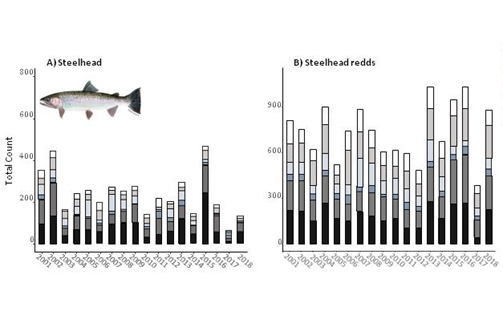
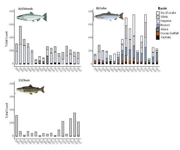
Adult Spawning Surveys 
Spawning surveys are conducted for Chinook, coho, and chum salmon, steelhead, and lamprey eels. All Surveys are coordinated with ODFW Oregon Adult Salmonid Inventory & Sampling Project for consistency. Data collected include numbers of each species and redds. Bio-information includes length, sex, scale samples (to determine age), collect snouts on tagged (hatchery) fish, DNA (when requested), and other basin specific projects. The surveys we do are:
  • Spring Chinook Float Surveys​​
  • Fall Chinook Walking Surveys
  • Fall Coho Walking Surveys
  • Winter Steelhead Float Surveys
  • Winter Steelhead Walking Surveys

Spring Chinook Float Surveys – Alsea & Siletz Rivers ​
  • ​Alsea River Surveys​:
    • ​Honeygrove Bridge to Schoolhouse Creek
    • South Fork Alsea to Schoolhouse Creek
    • Schoolhouse Creek to Salmonberry Park
    • Salmonberry Park to Digger Creek
    • Digger Creek to Big Riffle Ranch Road
  • Siletz River Surveys: 
    • Logsden to Twin Bridges
    • Twin Bridges to Illahee Park
    • Ojalla Bridge to Morgan Park

Coho, Chinook, Chum & Steelhead Walking Survey Results
  • Many of these surveys have had LWD Placement
  • Direct On Ground Observations & Documentation of Fish Use & Stream Changes Throughout the Winter & Spring
  • Steelhead Surveys Results
    • Alsea River Basin
    • Ocean Outfalls
    • Salmon River Basin
    • Siletz River Basin
    • Yachats River Basin
    • Yaquina River Basin
  • Coho/Chinook/Chum Survey Results
    • Alsea River Basin
    • North & South Beaver Creek
    • Ocean Outfalls
    • Rock Creek
    • Salmon River Basin
    • Siletz River Basin
    • Yachats River Basin​​
Picture
Picture
Picture
ODFW Northwest Oregon Habitat Data.
Picture
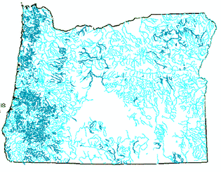
ODFW Aquatic Inventories Project stream survey data (dark blue) and rivers (light blue).

    Please contact our Program Staff with your questions or to request information about fish in your local watershed.

Submit

Our Services

Water Quality Program
Watershed Restoration & Enhancement
Invasive Species Control
Water Quality Monitoring
Fish Surveying & Habitat Assessment


Our District

District Staff
District Board of Directors
District History
About Lincoln SWCD

Support

Contact Us
Picture
Lincoln Soil and Water
Conservation District
Physical Address:
411 NE Avery St, Suite B

Newport, Oregon 97365

Phone: (541) 265-2631
Mailing Address:
P.O. Box 742 

South Beach, OR  97366

​Email: info@lincolnswcd.org

  • Home
  • Events
  • Services
    • Resources >
      • Technical Assistance
      • Invasive Species Control
      • Poisonous Plants of Lincoln County
    • What We Do >
      • Watershed Restoration, Enhancement, and Assessment >
        • Watershed Enhancement >
          • Siletz Focus Area
          • Technical Assistance >
            • Streambank Erosion
          • Conservation Plans
          • Conservation Incentive Programs
        • Water Quality Monitoring
      • Fish Surveying and Aquatic Habitat Asessment
      • Invasive Species Control
    • Partners
  • Contact Us