Water Quality Monitoring Program
Tracking the condition of water quality throughout Oregon's streams, lakes and rivers is a monumental task. Oregon Department of Environmental Quality (DEQ) is the State agency responsible for tracking, collecting and analyzing this information. To supplement their in-house monitoring, Oregon DEQ also supports community based monitoring known as Voluntary Monitoring to collect and provide additional regional data that would otherwise be unattainable given limited resources. All Voluntary Monitoring programs require written quality control and assurance plans that track the data quality to ensure only high quality data is accepted. Lincoln SWCD's water quality monitoring projects fall under this category.
Program Goals:
- Perform water quality sampling and analysis (monitoring) throughout Lincoln County watersheds to provide general, science-based information to inform landowners, the general public and our technicians about the quality of freshwater streams and rivers as they pertain to beneficial uses such as drinking water sources, recreation, aquatic farming (oysters), and aquatic life (fish, insects, etc.).
- Use the information as an educational tool and not as a way to create regulatory problems with specific landowners.
- Provide educational outreach to urban, rural and agricultural landowners about non-point source pollution causes and impacts.
- Provide the raw data that helps determine which water bodies that are not meeting (impaired) State water quality standards and that may be jeopardizing beneficial uses.
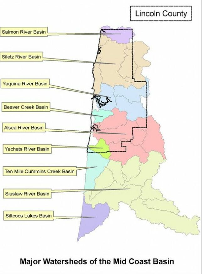
Watershed Profiles and Water Quality Data
|
Salmon River Basin
Location: Lincoln, Polk, Tillamook County Incorporated Areas: Otis, Redlodge Basin Size: 49,920 Acres Major Tributaries: Bear Creek, Little Salmon River, Salmon Creek, Slick Rock Creek, Treat River, Trout Creek Water Quality: 2010 303(d) listings for Salmon River, Salmon-Drift Creek Watershed Council Water Quality Monitoring Siletz River Basin Location: Lincoln, Polk County Incorporated Areas: Siletz, Logsden Basin Size: 197, 120 Acres Major Tributaries: Cedar Creek, Euchre Creek, Gravel Creek, North Fork, Rock Creek, South Fork, Sunshine Creek Water Quality: 2010 303(d) listings for Siletz River, LSWCD Water Quality Data 2011 - 2015 (excel file) Yaquina River Basin Location: Lincoln, Benton County Incorporated Areas: Newport, Toledo, Harlan, Eddyville, Burnt Woods Basin Size: 161,920 Acres Major Tributaries: Depot Creek, Big Elk Creek, Little Elk Creek, Mill Creek, Olalla Creek, Thornton Creek Water Quality: 2010 303(d) listings for Yaquina River, LSWCD Water Quality Data 2009-2015 (excel file) Beaver Creek Basin Location: Lincoln County Incorporated Areas: Seal Rock Basin Size: < 30,000 Acres Major Tributaries: North Fork, South Fork, Oliver Creek, Elkhorn Creek, Bowers Creel, Peterson Creek Water Quality: 2010 303(d) listings, LSWCD Water Quality Data 2010-2015 (excel file) |
|
|
Agricultural Water Quality Management Act (SB1010) |
In 1993, the Oregon Legislature passed the Agricultural Water Quality Management Act (Oregon Revised Statute 568.900 through 568.933).
The legislation directed the Oregon Department of Agriculture (ODA) to develop plans to prevent and control water pollution from agricultural activities and soil erosion on rural lands. ODA is also responsible for ensuring that farmers and ranchers help achieve water quality standards and meet the agricultural pollutant load allocations assigned by the Department of Environmental Quality (DEQ) in their Total Maximum Daily Loads (TMDLs). Water Quality TMDLs Program.
Because agricultural pollution is complex with mostly diffuse (nonpoint) sources, Oregon’s Agricultural Water Quality Management Program focuses on landscape conditions that support clean water and healthy watersheds. The Program uses various technical references to identify landscape conditions that should be achieved. The landscape-based approach provides landowners with certainty about their responsibilities and focuses on conditions within landowners’ control.
Farmers and ranchers must comply with the Area Rules, but how they comply is up to them. For example, regulations require farmers to prevent pollution from soil erosion. A farmer may use various ways to prevent erosion or control eroded soil. Options include no-till farming, installing sediment basins to catch eroded soil, farming along the contour of the field, and many other strategies.
Farmers may comply on their own or get help from others, including local Soil and Water Conservation Districts (SWCDs). ODA invites the local SWCD to attend each compliance investigation. SWCD technicians can provide suggestions during an investigation for strategies to correct water quality problems and work with a farmer or rancher after the investigation to address problems identified. ODA staff make a reasonable attempt to receive permission from the landowner or operator to enter land to conduct investigations. However, if permission is denied, ODA also has authority to enter lands as stated in ORS 568.915. During the investigation, ODA staff interview the landowner or operator, document observations, and gather data and photographs while onsite. Staff write thorough investigation reports that are reviewed by several other staff to ensure consistency. The program then sends a letter to the landowner describing their compliance status.
Enforcement actions are rare. If a problem is identified during an investigation, ODA gives the landowner an opportunity to correct the problem before taking enforcement action. This approach has been very successful, and the program is generally able to attain compliance through advisories and warnings.
How to file a complaint
The Oregon Department of Agriculture is charged with the investigation of situations that cause pollution of public waterways. The Department does not regulate odor, dust, or nuisance complaints caused by normal farming. Information received from Oregon's concerned citizens is vital to our efforts to protect the environment. If you believe that Oregon water quality laws have been violated, we urge you to submit an agricultural water quality complaint. While you are not required to use the form below, persons filing a complaint must submit it in writing and provide the information requested on the form. A signature is required for forms that are mailed or faxed. Completed complaints may be sent to:
Oregon Department of Agriculture
Water Quality Program
635 Capitol St NE
Salem, Oregon 97301
Fax: 503-986-4730
Email: jbyers@oda.state.or.us
Agricultural Water Quality Program Complaint Form
Water Quality Program
635 Capitol St NE
Salem, Oregon 97301
Fax: 503-986-4730
Email: jbyers@oda.state.or.us
Agricultural Water Quality Program Complaint Form
|
Mid Coast Agricultural Water Quality Management Area Plan 2017 Area Plan 2002 Administrative Rules 2017 Progress Report Mid Coast Executive Summary |
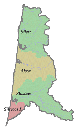
Mid Coast Basin consists of:
(1) all lands drained by the Salmon, Siletz, Yaquina, Alsea, Yachats, Siuslaw, Siltcoos, and Tahkenitch Rivers and their tributaries and
(2) all streams flowing directly into the Pacific Ocean between the Salmon and Tahkenitch watersheds.
|